


March 20th: This morning Holland woke up saying, "My Baby needs to get out of the house - let's go for a drive." He had a surprise up his sleeve ❤️

Today's Loop Route …


The Santa Fe Rail Line; Kingman-AZ

Destinations = We did the 1st & last notation, today; we will be driving to Bullhead City - with Aunt Gaye, on the 31st.
We drove to Oatman-AZ a different route, this afternoon: and it allowed us to see things we'd missed before, because they were behind us; and we were focused on the winding road ahead of us.
%20via%20Oatman%20Rd.png)
Oatman-AZ from Kingman-AZ; 48 min (28.8 mi) via Oatman Rd
Driving along, I saw some pretty big chunks of pumice littering the desert landscape on both sides of the highway; Holland was kind enough to turn around and take me back to the largest piece, so I could get a good look at it 😘

Pretty good hunk of pumice rock, alongside the roadway …
Arizona's Ancient Super Volcano:
(https://www.youtube.com/watch?v=x4BY0FeEovQ)
Although I have seen - and posted - many examples of pumice seen during our desert forays, this piece was the largest I have ever seen … and it got my mind going 🧐: Where did it come from? How large was the explosion that catapulted it to this location? Was it washed to this spot by a flash flood?
So, when I got back to Independence, I jumped online, to find out 😉
While Kingman-AZ, sits along the eastern edge of the Mojave Desert & is in a cold desert climate due to its plateau location; there is evidence of volcanic activity in Kingman's geologic past … and volcanic features noted in several areas of the Mohave County.
The San Francisco Volcanic Field - north of Flagstaff-AZ, is considered active; and future eruptions are anticipated.
The San Francisco Mountain composite volcano: the largest volcano in the field, and at 12,666 feet above sea level, the highest point in Arizona, is a composite volcano, also known as a stratovolcano … which is a cone-shaped volcano built up by layers of hardened lava, volcanic ash, and other volcanic debris, often characterized by steep sides and explosive eruptions. Similar in shape, and action, as the Mt. St. Helens volcano, in WA State.
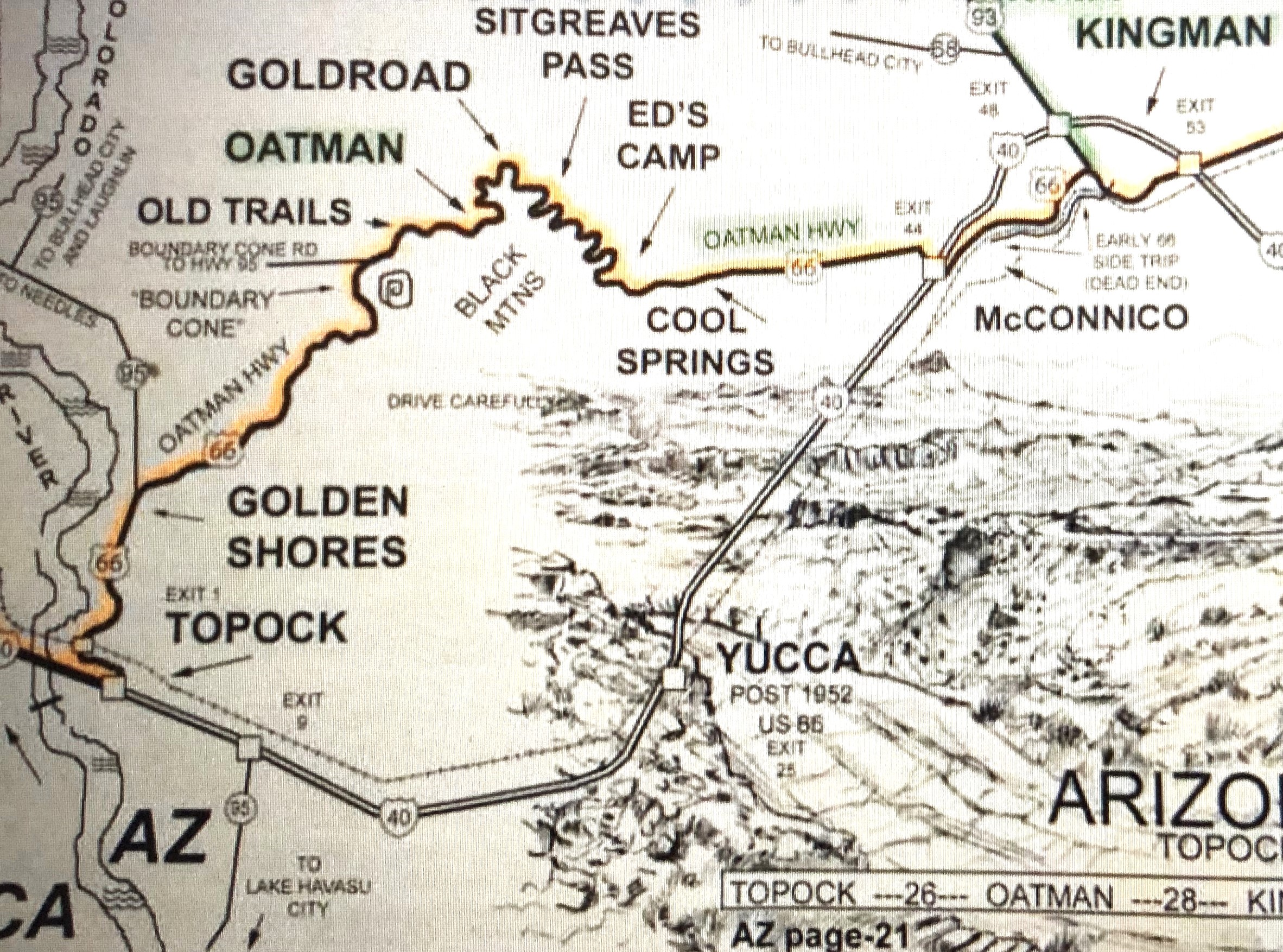
The prominent mountain peak behind Cool Springs Station in Arizona, is 'Thimble Butte' - a towering granite icon rising 1,400 feet above the valley floor spreading out along the Kingman-AZ to Oatman-AZ old highway Route 66. It is part of the Black Mountain Range that borders the Colorado River from Lake Mead to Topock-CA

Interesting mountain top~'Thimble Butte', part of the Black Mountains-AZ
The Black Mountains Of Northwest Arizona: (https://en.wikipedia.org/wiki/Black_Mountains_(Arizona))
The Black Mountain Range is 75 miles of jagged volcanic peaks and rhyolite formations along the west border of Mohave County. They’re so rugged that only a handful of roads cross through them … even Interstate 40 loops 60 miles south to avoid the range.

Coming into the 'Cool Springs Station'; #8275 Oatman Road, Historic Rte 66, Golden Valley, AZ
The History of Cool Springs~Route 66-AZ: (https://www.route66coolspringsaz.com/history.htm)
While Holland went inside the Station building, I walked over to the stenciled Historic Route 66 icon, to get a picture of it - I would have shown the tips of my toes, included … but I was already pushing my luck with a couple motorcyclists that were chomping at the bit to boogie down the highway.
.JPG)
I held up a couple motorcycles, by standing in the middle of the highway to get this Historic US 66 photo shot 😉


Vintage 'Cool Springs' Postcard; circa 1926
Cool Springs-AZ was once a hustling and bustling pit stop for travelers along Route 66 who were about to ascend (or descend; depending on the direction traveled) the dangerous climb up/down Black Mountain & Sitgreaves Pass.
I was a little envious of the lucky people to be living and working in such a beautifully scenic area. When I let fly, "These people are lucky dogs to be situated in - and surrounded by all this beauty" … Holland barked a laugh, and threw in, "I'll bet 'those lucky dogs' don't feel so lucky when the summer temperatures reach 3 digit readings."
This section of Route 66 is one of the few remaining that is still a very narrow two-lane highway and believe me, you want to take it slow and steady: in one place, looking out my passenger-side window, I could see where the sandy-grit foundation under the blacktop, was seriously being eroded away. There are no roadside [shoulders], and the drop-away's from roadsides are steep & deep. We could see several wrecked vehicles sitting at haphazard angles where they had plunged off the roadway and came to a crashing rest in the desert grit.
Today vehicles over 40 feet long are not allowed on this section - Betsy's probably 20 feet long from bumper to bumper (and it's a chancy drive 🤔, alone) … Independence is 45 feet long; combined, they would be a suicidal hazard 😳 along this stretch of Route 66.

A cave!


There's an artesian well, at the top of those stone steps … Betsy was too long to fit into that teeny turnout; and it was entirely too close to the oncoming blind curve.
Shaffer Springs~aka, Shaffer's Fish Bowl: (https://en.wikipedia.org/wiki/Shaffer_Springs)

Internet pic of the spring water basin; Shaffer Springs~Shaffer's Fish Bowl

White burros really stand out against the brown gritty desert landscape.
We also caught sight of a big operation mine: internet searches tell me [While the Oatman Mining District, including Sitgreaves Pass, has a rich history of gold mining, no major, modern-day mining operations are currently operating within Sitgreaves Pass itself] … we beg to differ: there was a clear sign of mining taking place, in Sitgreaves Pass, which was the road we drove; and is located on Route 66, which connects Oatman with Kingman (and visa versa).
Given the hardware & machinery - this is clearly an operational & functioning mining outfit; Sitgreaves Pass-AZ
Gold Road Mine-AZ:
(https://www.legendsofamerica.com/az-goldroad/)

Operational & Functioning
Climbing upwards, I spotted a stone building ruins - barely off the side of the curving bend of roadway; I later learned that this would have been Gold Road-AZ - which was a small mining area … which was part of the larger Oatman Mining District.

Nearly hidden ruins of a cabin that was part of the mining activity and the early days of Route 66.
Oatman-AZ & Goldroad-AZ: (https://azoffroad.net/oatmangoldroad & https://www.cornerstone-environmental.com/publications/item/goldroad-and-the-oatman-mining-district)

1906~Gold Road Mine; Oatman Mining District, Black Mtns-AZ


2-toned peak; coming into Oatman-AZ

2-toned peak showing in this vintage pic of the Tom Reed Mine; Oatman-AZ
The Tom Reed Gold Mine-AZ:
(http://lostmines.net/tom-reed-gold-mine.html)

The longest remaining segment of Route 66 of it's U.S.A. route, & ends at end of Oatman Hwy-AZ
Between 1870 and 1980, the Oatman District produced more than one million ounces of silver and nearly two million ounces of gold.
When we came into Oatman, I saw a familiar figure: the little donkey plodding up main street looked like the one that has a sticker, "Do not feed me" taped to it's forehead, last time we were here. Holland said they don't grow up that fast … but, it sure looked like it was the same cute, little, furry beast 😉

.JPG)
Baby donkey; now & then~Oatman-AZ
My 1st Oatman-AZ Post: (https://roadgypsiesvalandholland.blogspot.com/2024/12/redemption-pt-1oatman-az.html)
Exiting the busy (meandering four-footed, & two-footed, hoofers) Main Street of Oatman … we pulled over and spent some time enjoying the furry beggars.
This time, we had donkey snacks with us 😁
Holland feeding animal cookies to roadside beggars. LOL
~Oatman%20Rd.-AZ.JPG)

Moochers on my side of Betsy - and a bonus baby, too; Oatman Rd-AZ


It's just adorable!

The last group of wild donkeys on the Historic Route 66 highway, quickly coming to an end.

Leaving, I chucked a few cookies towards the strolling donkeys, out the passenger side window … but a gust of wind blew my handful of cookies onto Betsy's hood - Holland was silent, but his eyes spoke volumes. Betsy is his true 'Baby'; and he is very picky with the 4x
Pulling back onto the blacktop, the errant animal cookies flew off Betsy's hood and were no doubt nimbly picked up out of the dust, and savored by one of the pampered wild donkeys 👍
In no time at all, we had reached the end of the Historic Route 66 - and Holland was back to zipping up the Interstate. He does these backroad Daytrips for me, but the freeway is his main preference for travel.
.JPG)
We have now traveled the entire length of AZ's Historic Route 66 - Seligman-AZ yesterday; & Oatman-AZ, today.

The Colorado River; Historic Rte 66, Topock, AZ
%20via%20I-40%20E.png)
Kingman-AZ fro Topock Railroad Water Tower-AZ; 48 min (49.6 mi) via I-40 E
We had an enjoyable day out-of-house.

Heuy Lewis & the News - 'Doing It All For My Baby' Lyrics: (https://www.youtube.com/watch?v=aN6JClwqpEM)

It was a good surprise; and a fun, sunny day excursion 👩❤️💋👨
